Take your remote sensing capabilities to the next level with the LiDAR Remote Sensing Payload Instrument (RESEPI) from Inertial Labs. An affordable solution for extremely accurate remote sensing applications, RESEPI is a compact, low power, lightweight system, designed to fit the size and power requirements of any project allowing your drone to fly longer and collect more data. RESEPI’s highly automated software suite with automatic RTK LAS file generation, along with a one-click command-line interface, makes point cloud generation swift and simple. Compatible with numerous LiDAR sensors, and easily integrated with your UAV platform, RESEPI is suitable for a range of applications, from utility inspection and site monitoring to scanning, mapping and precision agriculture. LiDAR sensor not included - browse our range here
Speak to an expert
Although robots are great, it’s actually best talking to our humans to get advice and support on your autonomy journey…
It’s all in the detail
Product description
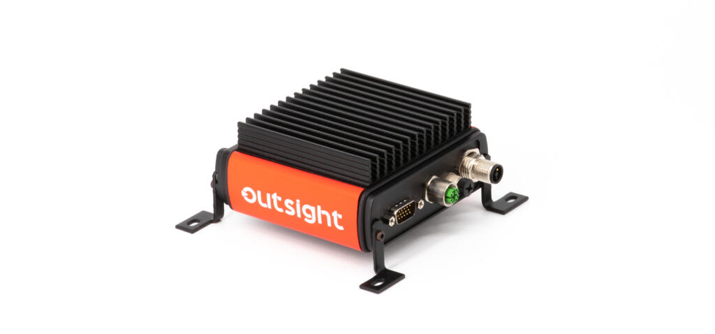
A combined Dual Antenna GNSS-Aided Inertial Navigation System, datalogger, LiDAR, camera and communications system, RESEPI offers real-time and post-processed generation of point cloud solutions. The processing platform contains a WiFi interface, embedded cellular modem to support RTCM corrections, data logging software and gigabit ethernet.
RESEPI can be used with commercially available LiDARs, including Ouster, Velodyne, Quanergy, RIEGL, LIVOX, with all components mounted into one compact and light-weight enclosure, and can be easily integrated with a range of drone platforms.
Highly customisable design, a level above other remote sensing payloads
LiDAR scanners vary in several key specifications, including; maximum AGL (above ground level), range accuracy, scan rate and field of view, while different scanning applications will have different requirements that not all LiDAR sensors will be able to meet.
The INS-D-OEM is easily integrated with many of the top LiDAR scanners meaning that RESEPI can be used in a wide range of applications with varying requirements. In addition to the LiDAR integrations, RESEPI has also been designed to work with stereo cameras, such as the Sony A6000 for photogrammetry, and the Blackfly FLIR.
Real-time logging
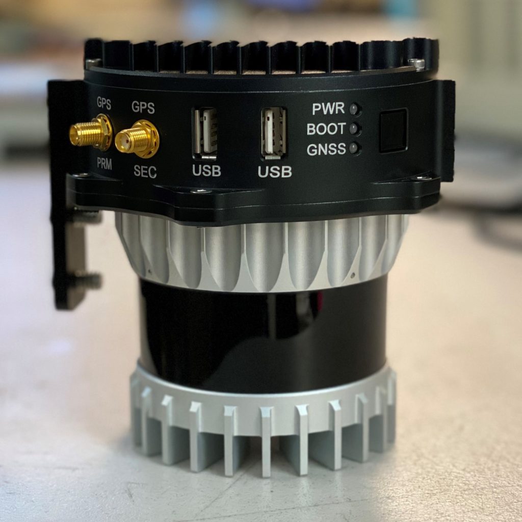
Featuring a comprehensive interface both in and out of flight, RESEPI displays what devices are connected and information from the data logger, which includes inertial data, LiDAR data points, base station data, and raw GNSS data. If RESEPI is integrated with a camera in addition to LiDAR, the interface will show the number of images captured from the camera device. Each category of data from the data logger makes up the components required for generating a point cloud. If using a real-time solution, then data logging features the ability to have a scan file generated at the time of scan completion.
Future development
The development pipeline will see RESEPI paired with NVIDIA graphics cards to enable real-time data processing and object recognition, avoidance and SLAM based navigation, opening up further applications in autonomy. Additionally, RESEPI can be sensor fused with many types of optical data which is currently limited to stereo cameras, however, future collaborations will see development with multiple LiDAR sensors, thermal cameras, stereo cameras, infrared cameras and other sources of optical data.
Features
- Up to 1 TB USB memory drive
- Up to 200 metre AGL
- USB camera interface
- WiFi and GSM – embedded WiFi and cellular modem
- PPK / RTK – dual/single GPS aided INS
- 3-5 cm point cloud accuracy
- Weight without LiDAR – 0.37 kg
- Power draw without LiDAR – 4 Watts
- Compatible with commercial LiDAR scanners including; Ouster, Velodyne, Quanergy, Livox and more
- Easily integrated with a range of drone platforms
- Modular design makes RESEPI fully customisable
Applications
- Remote sensing
- Scanning and mapping
- Precision agriculture
- Simultaneous Localisation and Mapping (SLAM) algorithm development
- Utility inspection
- Construction site monitoring
Specifications
See ‘Specifications for different LiDAR models’ tab above for tailored capabilities
| Weight (without LiDAR) | 0.37 kg |
| Power consumption (with VLP-16 LiDAR) | 12 W |
| Position accuracy (GPS aided INS) | 0.5 cm (PPK estimated) / 1 cm + 1 ppm (RTK) |
| Attitude accuracy (GPS aided INS) | <0.01° pitch and roll <0.05° heading |
| Precision (point cloud) | 3 – 5 cm (dependent on LiDAR, taken on the same target @ 50 m AGL) |
| Scanner field of view | 360° (dependent on LiDAR) |
| Compatible LiDAR scanners | Ouster, Velodyne, Quanergy, Livox. Can be calibrated for use with many commercially available brands |
| Inertial Navigation System | Inertial Labs INS-B-OEM, INS-D-OEM |
| Recorded data | GNSS data for PPK GNSS time-stamped INS and IMU data GNSS time-stamped LiDAR scans GNSS time-stamps for camera strobe pulses |
Finance and Shipping
Finance and Shipping
Restrictions on customers
Please note that due to the high average transaction costs, we must adhere to Anti-money laundering legislation. For new customers, this comes into effect when the transaction value is more than £8,800 (or equivalent in USD or EUR).
Please note that some products are restricted so we typically do a brief check on location and customer information before accepting self-service orders.
Online ordering (self service)
On orders up to £8,800 (or equivalent in USD or EUR), we offer online ordering with payment by all major credit cards. Payments can be made in GBP only.
Payment options for transactions over £8,800
Please contact us to complete our ‘Know Your Customer’ form for payments in advance (by BACS or Card) above this amount, or apply for a full ‘Credit Account’ for up to 30 days credit, on account. Payments can be made in GBP, EUR or USD.
Shipping
Shipping by default is by FedEx and typically takes from one to five working days worldwide. All packages are fully insured from us to you.
Our incoterms are DDP (for UK customers) and DAP (for international customers, including EU). Other incoterms may be available on request in special circumstances.
Goods can also be collected from our logistics centre.
Loan finance
Level Five Supplies is pleased to offer finance as a payment option, iur appointed partners can work with you to make equipment purchase more straightforward.
There are many reasons to consider using finance:
- Improves Cash Flow: When you finance your equipment, your cash isn’t tied up in the equipment. Instead, it’s free for other investments that will grow your business, produce income, and ensure the equipment you acquire earns profits over its lifetime.
- Preserves Other Lines of Credit: Tomorrow can bring many opportunities. Financing equipment means you’ll have the credit available (either from the bank or other sources) to take advantage of future opportunities.
- Hedges against inflation: Your monthly payment remains the same over the term of the lease or loan. Money paid later in the term usually have less purchasing power than those paid at the beginning of the term…so you pay for today’s equipment needs with tomorrow’s lower-value currency.
- Provides 100% financing: Even “soft costs” such as training, shipping, installation, and maintenance agreements can usually be included. So you can rest easy knowing that these associated costs won’t disrupt your cash flow.
- Simplifies equipment changes: Hiring additional workforce? Increasing efficiency? Additional equipment can easily be added to your existing loan or lease. Or, if you’re trying to stay ahead of the competition by staying ahead of technologies, the equity in your financed equipment can be applied toward the loan or lease of new equipment. These options solve the problems of obsolescence – and make your job easier.
- Eliminates hidden charges: You have no compensating balances, no closing costs, and no blanket liens or other restrictive covenants that banks use to increase customers’ cost. What you see is what you get.
- Offers excellent rates: Our finance partner rates are highly competitive.
- Saves on taxes: Depending on the type of finance agreement you select, as much as 100% of your payments may be tax deductible.
- Offers many payment programs: Our finance partners work for you, not us. You choose the type of loan or lease that best fits your needs, and you select the length of the loan or lease term.
The finance agreement is between you and the lender, and we don’t take commission or referral fees – but we’ve done the preparatory work of allocating a broker for the US, and another for Europe, explaining the technology, validating supplier products and explaining how the technology will be used so your application process is simplified and focused entirely on the financials.
The initial part of the process usually takes less than an hour and means that you can spread the cost of a higher value purchase of equipment like this over several months or even years, allowing you to better plan your project or department budgets, but also means you can get what you need over the coming years, not just what you can afford today.
Contact our Sales team to discuss your needs further.